
Google Earth Adds Historical Street View and New AI Environmental Insights

As part of its 20th anniversary, Google Earth has introduced a major update that lets users explore historical imagery from Street View, providing a visual record of how locations have evolved over time. Google Earth Historical Street View is new feature, because previously, users could switch to Street View while browsing satellite images, but now they can also scroll through a timeline of images captured in previous years—mirroring a feature already available in Google Maps.

This addition follows last year’s rollout of historical satellite and aerial imagery, which was once exclusive to the Earth Pro desktop application. With these updates, Google Earth application continues to expand its ability to help users observe and understand changes in the world’s landscapes and cities.
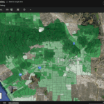
Alongside Google Earth Historical Street View, Google is preparing to introduce new AI-driven tools aimed at professional users. Among the upcoming features are insights into tree canopy coverage, enabling users to identify shaded areas and locations that may benefit from additional cooling. Another tool will provide access to land surface temperature data, useful for tracking urban heat patterns and informing environmental planning.
Google says these new AI-powered insights will become available in the coming weeks, further cementing Earth’s role as a critical tool for both casual explorers and environmental professionals.


